
4. Setting domain properties#
This file sets general properties of analysis domain (whether a river basin, crop fields, etc..). Variables to be set are listed in Table 4.1.
Keyword |
Description |
Requirements |
|---|---|---|
|
this map sets the domain of simulation and coordinate reference system. All new variables created at runtime use mask as reference grid. All maps must have the same extent and coordinate reference system of mask, unless differently specified. |
mandatory |
|
Ground albedo |
optional |
|
Land cover map according to level 3 Corine project classification. |
optional |
|
Soil texture map according to USDA classification scheme. |
optional |
The following example sets mask and albedo of a river basin stored in ESRI-ASCII grid format using UTM 32N datum ED50 as coordinate reference system (epsg code 23032).
#   set domain properties

[mask]
  file = ./data/mask.asc
  format = esri-ascii
  epsg = 23032

[albedo]
  file = ./data/albedo.asc
  format = esri-ascii
  epsg = 23032
4.1. Land cover#
Land cover assignment in FeST model is based on the three levels system provided by CORINE land cover program. In the early 1980’s, the European Commission recognized the need for a comprehensive, detailed, and harmonized dataset on the land cover and land use of the European continent. The European Commission launched the CORINE (Coordination of Information on the Environment) program in an effort to develop a standardized methodology for producing continent-scale land cover, biotope, and air quality maps. In its current form, the CORINE Land Cover (CLC) product offers a pan-European land cover and land use inventory with 44 thematic classes, ranging from broad forested areas to individual vineyards. The classification is organized in three levels with the following main classes:
Artificial areas
Agricultural areas
Forest and semi-natural areas
Wetlands
Water bodies
Code CLC |
Name |
|---|---|
111 |
Continuous urban fabric |
112 |
Discontinuous urban fabric |
121 |
Industrial or commercial units, public services and military in- stallations |
122 |
Road and rail networks and associated land |
123 |
Port areas |
124 |
Airports |
131 |
Mineral extraction sites |
132 |
Dump sites |
133 |
Construction sites |
141 |
Green urban areas |
142 |
Sport and leisure facilities |
211 |
Non-irrigated arable land |
212 |
Permanently irrigated arable land |
213 |
Rice fields |
221 |
Vineyards |
222 |
Fruit trees and berry plantations |
223 |
Olive groves |
231 |
Pastures |
241 |
Annual crops associated with permanent crops |
242 |
Complex cultivation patterns |
243 |
Land principally occupied by agriculture, with significant areas of natural vegetation |
244 |
Agro-forestry areas |
311 |
Broad-leaved forest |
312 |
Coniferous forest |
313 |
Mixed forest |
321 |
Natural grassland |
322 |
Moors and heathland |
323 |
Sclerophyllous vegetation |
324 |
Transitional woodland/shrubs |
331 |
Beaches, dunes, and sand plains |
332 |
Bare rock |
333 |
Sparsely vegetated areas |
334 |
Burnt areas |
335 |
Glaciers and perpetual snow |
411 |
Inland marshes |
412 |
Peat bogs/Mires |
421 |
Salt marshes |
422 |
Salines |
423 |
Intertidal flats |
511 |
Watercourses |
512 |
Water bodies |
521 |
Coastal lagoons |
522 |
Estuaries |
523 |
Sea and ocean |
Note
Details about Corine land cover classification can be found here: https://land.copernicus.eu/content/corine-land-cover-nomenclature-guidelines/html.
4.2. Soil texture#
Soil texture indicates the relative content of particles of various sizes that make up the mineral fraction of the soil. Soil texture focuses on the particles that are less than two millimeters in diameter which include sand, silt, and clay.
The United States Department of Agriculture (USDA) defined twelve major soil texture classes: sand, loamy sand, sandy loam, loam, silt loam, silt, sandy clay loam, clay loam, silty clay loam, sandy clay, silty clay, and clay. Soil textures are classified by the fractions of each soil separate (sand, silt, and clay) present in a soil. Classes are typically named for the primary constituent particle size or a combination of the most abundant particles sizes, e.g. “sandy clay” or “silty clay”. A fourth term, loam, is used to describe equal properties of sand, silt, and clay in a soil sample, and lends to the naming of even more classifications, e.g. “clay loam” or “silt loam”.
Determining soil texture is often aided with the use of a soil texture triangle plot. One side of the triangle represents percent sand, the second side represents percent clay, and the third side represents percent silt. If the percentages of sand, clay, and silt in the soil sample are known, then the triangle can be used to determine the soil texture classification. For example, if a soil is 70 percent sand and 10 percent clay then the soil is classified as a sandy loam. The same method can be used starting on any side of the soil triangle.
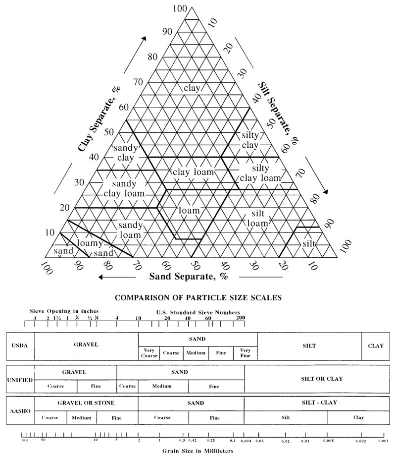
Fig. 4.1 Soil texture triangle, showing the 12 major textural classes, and particle size scales as defined by the USDA (source: https://commons.wikimedia.org/wiki/File:SoilTextureTriangle.jpg).#
The texture classes and the corresponding id internally used by FeST model are listed in Table 4.3.
Id |
Soil texture class |
|---|---|
0 |
Texture unknown |
1 |
Clay |
2 |
Silty Clay |
3 |
Sandy Clay |
4 |
Clay Loam |
5 |
Silty Clay Loam |
6 |
Sandy Clay Loam |
7 |
Loam |
8 |
Silty Loam |
9 |
Sandy Loam |
10 |
Silt |
11 |
Loamy Sand |
12 |
Sand |