
5. Morphological properties#
This file sets morphological properties of investigated domain. In this file the user can set 3 maps
(digital elevation model, flow direction and flow accumulation) as listed in Table 5.1.
When flow direction map is assigned, the flow direction convention among ESRI and GRASS must be specified
Keyword |
Description |
Requirements |
|---|---|---|
|
Digital elevation model |
optional |
|
Flow direction according to D8 approach and ESRI convention (Figure 5.1) |
optional |
|
Set flow direction conventions choosing among ESRI (NW=32, N=64, NE=128, W=16, E=1, SW=8, S=4, SE=2) and GRASS (NW=3, N=2, NE=1, W=4, E=8, SW=5, S=6, SE=7) |
Required by |
|
Flow accumulation in number of cells |
optional |
There are eight valid output directions relating to the eight adjacent cells into which flow could travel. This approach is commonly referred to as an eight-direction (D8) flow model and follows an approach presented in [Jenson and Domingue, 1988]. ( Fig. 5.1 )
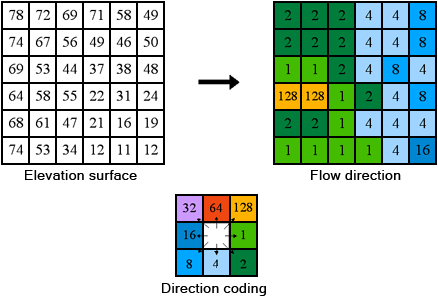
Fig. 5.1 The coding of the direction of flow according to ESRI convention. (source: https://pro.arcgis.com/en/pro-app/latest/tool-reference/spatial-analyst/how-flow-direction-works.htm)#
When the optional section [stream-network] is present in the morphological properties configuration file, the topology of river network is created starting from information of elevation, and flow direction. This information is used when computation cannot be performed on a raster in arbitrary order, like for river discharge routing that requires to start from source nodes and going on till the basin outlet following the Horton stream order topology. The stream network is space filling that means that every single cell of the domain is crossed by a reach. The keywords for setting stream network delineation are listed in Table 5.2.
Keyword |
Description |
Requirements |
|---|---|---|
|
marks the beginning of section |
optional |
|
maximum rach length value [m]. When a reach longer than this value is detected it is split in sub-reaches so that they are lower than maximum |
Optional. When keyword is missing, reaches are not split whatever their length is. |
|
While computing the reach slope, when a negative slope is found, it is corrected with this value. Unit is m/m. |
Optional. The correction prevents that run-time error occurs when discharge routing is computed. When keyword is missing, negative values are left unchanged. |
|
A plain text file is exported with topology information |
Optional. Possible values: 1=export file, 0=do not export file. When keyword is missing file is not written. |
|
A line vector shape file is created with reaches and |
Optional. Possible values: 1=export file, 0=do not export file. When keyword is missing file is not written. This option is available only on Windows operating system machines |
The following example sets digital elevation model, flow direction, and flow accumulation maps stored in ESRI-ASCII grid format using UTM 32N datum ED50 as coordinate reference system (epsg code 23032). Stream network is derived from dem and flow direction with a constraint on the maximum length of single reach of 2000 m, negative values of reach slope are corrected to 0.0005 m/m. No any files are written.
#   set morphological properties

[dem]
  file = ./data/dem.asc
  format = esri-ascii
  epsg = 23032

[flow-direction]
  file = ./data/flowdir.asc
  format = esri-ascii
  epsg = 23032
  flow-direction-convention = esri

[flow-accumulation]
  file = ./data/flowacc.asc
  format = esri-ascii
  epsg = 23032

[stream-network]
  max-reach-length = 2000
  negative-slope-correction = 0.0005
  file-export = 0
  shp-export = 0