
1. FeST model scheme#
The FeST model is a spatially distributed model. The simulation domain is discretized into regular square cells (typical application range: 10-5000 m) within which equations that describe hydrological processes are solved with a time step according to the available meteorological input data, the simulated processes, a nd the characteristics of the simulation domain (area, slope, etc..) that is usually set in the range 1 hour - 1 day.
The FeST model is written in Fortran 90 with a modular approach so that only the dominant processes can be simulated for any specific studies ( Fig. 1.1 ). As an example, the snow module that simulates snow melt and accumulation is not relevant for simulating hydrological balance of a tropical river basin but it is fundamental when the simulation of snow melt is required for managing hydropower production over the Alpine mountains.
For running a simulation, the FeST model requires meteorological input data. These can be site measurements acquired by meteorological stations or multidimensional raster data coming from weather forecast or climatic mathematical models. Station site data are interpolated over the simulation domain using different algorithms such as, Thiessen (1911) polygons, inverse distance weighted, or Kriging methods. Specific methods are implemented to account for topographic effect on air temperature, solar radiation, and wind speed. Gridded air temperature data that are usually at a coarser spatial resolution than spatial step of hydrological simulation, are downscaled to higher resolution considering actual elevation from the digital elevation model. The snow module gets precipitation data, both from rain gauges and gridded dataset, and simulate snow accumulation, as snow water equivalent, and melting. The glacier module simulates glacier melting and interacts with snow module for glacier accumulation. The soil balance module computed evapotranspiration, infiltration, runoff, percolation and updates soil moisture. Some state variables are shared with plants module such as soil moisture and leaf area index, so that there is a mutual interaction between soil balance and plants modules. Drainage from soil balance is used as groundwater recharge. Runoff is the source term of routing module that simulates flow discharge. The resulting discharge time series can be affected by natural or artificial regulated reservoirs or bypass channels.
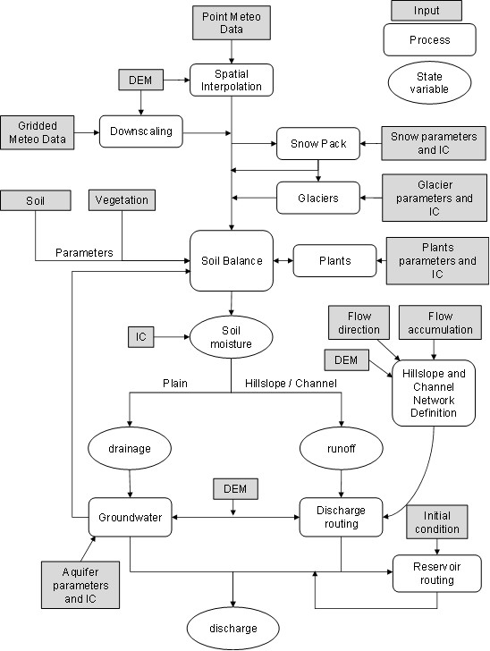
Fig. 1.1 Scheme of hydrological processes implemented within FeST model with main state variables and input data#